Rationale
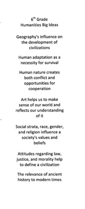
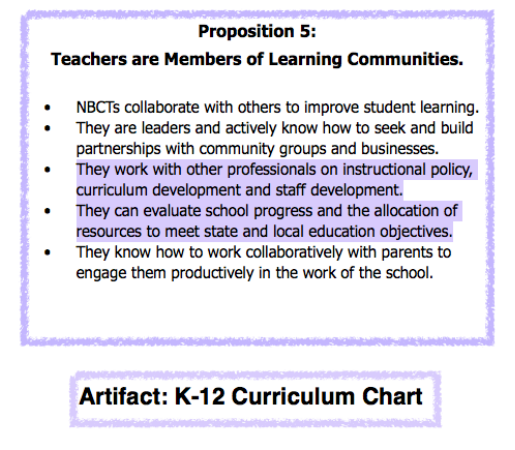
This year, I was very fortunate to participate in Berwick Academy’s K-12 curriculum mapping. The pictures below depict groups of brainstorming faculty from both the History and English departments. The chart I created is the documentation of the items written on the board during the English Department’s meeting to comb out the K-12 curriculum. It is a preliminary piece of the English department’s (K-12) curriculum puzzle. I have chosen it to represent the “evaluates school progress & meets objectives” part of Proposition 5, as many ongoing discussions arose out of this meeting that helped translate the bigger picture into daily classroom activities and objectives. I have also included here the list of "big ideas" that came out of the History department's first meeting in the summer, as it gives a good sense of the general nature of the early conversations among colleagues searching for the answer to the question, "What's the big idea?".
This year, I was very fortunate to participate in Berwick Academy’s K-12 curriculum mapping. The pictures below depict groups of brainstorming faculty from both the History and English departments. The chart I created is the documentation of the items written on the board during the English Department’s meeting to comb out the K-12 curriculum. It is a preliminary piece of the English department’s (K-12) curriculum puzzle. I have chosen it to represent the “evaluates school progress & meets objectives” part of Proposition 5, as many ongoing discussions arose out of this meeting that helped translate the bigger picture into daily classroom activities and objectives. I have also included here the list of "big ideas" that came out of the History department's first meeting in the summer, as it gives a good sense of the general nature of the early conversations among colleagues searching for the answer to the question, "What's the big idea?".
Reflection
Global Positioning Systems are very helpful when navigating one’s way to a destination. However, even though these devices employ miraculous technology, they still require a destination to be keyed in before they can perform their functions as guides. The same holds true for teachers, who must first identify their destination before heading into the forest of knowledge with their students. Before a destination can be chosen, though, a map of the surrounding area must first be created. In the case of academics, this map is drawn in two dimensions: by subject matter and by grade level. This process is designed to elucidate the objectives within each discipline, but also to give K-12 faculty the opportunity to comb through the curriculum in search of gaps and redundancies.
This mapping experience was quite valuable to me , as it allowed me a straightforward look at the curriculum-making process. I also became familiar, through this experience, with the deepened sense of purpose about teaching a subject that arises from an awareness of the bigger picture.